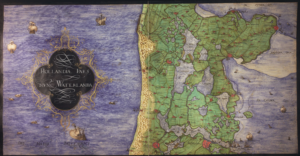
Around 1573, cartographer Christiaan sGroten created an atlas of the Netherlands and Germany for the King of Spain. At this time, the Netherlands were part of the Habsburg empire, headed by King Philip II of Spain. The Dutch Revolt had started several years earlier and the Spanish king needed maps for strategic purposes and commissioned the atlas. The atlas has been digitized and is available at the Royal Library of Belgium. The map we are looking at this week shows a part of the province of … [Read more...]
Dutch term – Omnummeren
Omnummeren means to renumber. In the past, addresses often changed from one census/population register to the next. The houses would be omgenummerd; renumbered. This can make it difficult to find the modern locations of historical addresses. See tips for finding the address where your ancestors lived for some ideas. Some archives have omnummerlijsten (renumber lists) or omnummerregisters (renumber registers), either created in the past and part of their records, or created in the modern … [Read more...]
Map of the week – Trade map of the Netherlands, 1894
This week we are looking at a map of routes from 1894. Understanding the major connections between cities may help you understand migration patterns. People who travelled along these lines may have met partners in other towns, or found work in a different place. You can zoom in at Gallica. The map indicates different types of routes: Bold solid orange lines represent railroads. Bold dashed orange lines represent trams. Thin solid orange lines represent streets with regular … [Read more...]
Member of the Editorial Board of the Record
I am excited to announce I have joined the editorial board of the New York Genealogical and Biographical Record. The Record, as it is colloquially known, is a peer-reviewed journal focused on scholarly research into New York families. The Record has appeared for more than 150 years and is the second oldest genealogical journal in English that is still being published today. It is published by the New York Genealogical and Biographical Society. The Record often features families who lived in … [Read more...]
Map of the Week – Aalten, 1867
Between 1865-1868, Jacob Kuyper published a series of atlases with municipal maps. These show the location of all the hamlets, villages, and larger towns in the municipality, as well as the main roads and railroads. The Kuyper maps are often available at the websites of archives or via Wikimedia Commons. This week we are looking at a map of Aalten in 1867. Interestingly, the map does not include Bredevoort in the colored outline of the municipality, even though Bredevoort had been part of the … [Read more...]
Dutch Genealogy News for September 2024
Here is an overview of the new sources, projects, and other news from the last month. Sources Death records of various municipalities in Noord-Brabant 1971-1973 have been digitized and indexed and can now be consulted via the Brabants Historisch Informatie Centrum. The Nieuwe Texelsche Courant 1896-1930, a newspaper for the island of Texel, is now available via the Regionaal Archief Alkmaar. A transcription of the orphan chamber records of Bodegraven 1619-1724 is now available via … [Read more...]
Map of the week – Water boards in Drenthe, 1958
This week, we are looking at a map of waterschappen (water boards) in Drenthe in 1958. In the Netherlands, are responsible for the management of water, including flood prevention and drink water. Each region has its own water board. The boundaries of the water board are often determined by features in the landscape, such as rivers or dikes. The area covered by a water board can differ substantialy from the division in municipalities. The map shows that the boundaries of the water boards in … [Read more...]
Dutch term – Boomgaard
A boomgaard is an orchard. In older records, you may see the word spelled as boomgaerd, bogaerd, or even bongerd. You may come across the term in land records. Some last names are derived from the word boomgaard: Van den Bogaerd, Van den Bogert, and even the Latinized Bogardus all mean "from the orchard." … [Read more...]
Map of the Week – Zeeland, 1659
In 1659, the famous mapmaker Joan Blaeu published his world atlas Tooneel des Aardrycks [Display of the Realm of Earth]. The archives in Leiden have made their atlas available online. This week we are looking at a map of Zeeland. Compared to a modern map, the province had many more islands in 1659. In this period, people were trying to reclaim land from the sea, but floods sometimes inundated whole regions. The map shows many drowned areas that were later reclaimed from the sea again. See the … [Read more...]
Quick tip – Access Restrictions For People Born More Than 100 Years Ago
In the Netherlands, privacy laws restrict access to records of people who may still be alive. But this often affects records of people who were born (much) earlier too. A few examples: Death records are only public after 50 years. My great-grandmother was born in 1893 but her death record only became public this year because she was 80 years old when she died. Notarial records become public after 75 years. If a person born in 1880 makes a will in 1970, their will only becomes public … [Read more...]


