
A kerkdienst is a church service. In most places in the Netherlands, churches are no more than 10 km (6 miles) apart, so anyone can walk to church within an hour (two if the roads are muddy). In the image below we see a group of people leaving a church, drawn around 1654. At that time, churches were not heated. We can tell this service took place during the colder months. Several women have their hands in muffs, and some are carrying a little stove which would have held some hot coals to … [Read more...]
Map of the Week – Leiden, 1574
30 September 2024 by Leave a Comment

This week we are looking at a map of Leiden from the atlas Civitates Orbis Terrarum by Braun and Hogenberg. The map dates from 1574, during the Eighty Years' War or the Dutch Revolt, whereby the Netherlands fought for independence from the Habsburg Empire, ruled by King Philip II of Spain. 1574 is a key year in Leiden's history. The city was besieged by Spanish troops for months, but the townsfolk refused to surrender despite food shortages. They managed to get a message out to William … [Read more...]
Map of the week – Waterland, circa 1573
23 September 2024 by Leave a Comment
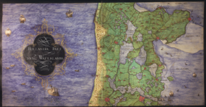
Around 1573, cartographer Christiaan sGroten created an atlas of the Netherlands and Germany for the King of Spain. At this time, the Netherlands were part of the Habsburg empire, headed by King Philip II of Spain. The Dutch Revolt had started several years earlier and the Spanish king needed maps for strategic purposes and commissioned the atlas. The atlas has been digitized and is available at the Royal Library of Belgium. The map we are looking at this week shows a part of the province of … [Read more...]
Map of the week – Trade map of the Netherlands, 1894
16 September 2024 by Leave a Comment

This week we are looking at a map of routes from 1894. Understanding the major connections between cities may help you understand migration patterns. People who travelled along these lines may have met partners in other towns, or found work in a different place. You can zoom in at Gallica. The map indicates different types of routes: Bold solid orange lines represent railroads. Bold dashed orange lines represent trams. Thin solid orange lines represent streets with regular … [Read more...]
Map of the Week – Aalten, 1867
9 September 2024 by 3 Comments

Between 1865-1868, Jacob Kuyper published a series of atlases with municipal maps. These show the location of all the hamlets, villages, and larger towns in the municipality, as well as the main roads and railroads. The Kuyper maps are often available at the websites of archives or via Wikimedia Commons. This week we are looking at a map of Aalten in 1867. Interestingly, the map does not include Bredevoort in the colored outline of the municipality, even though Bredevoort had been part of the … [Read more...]
Map of the week – Water boards in Drenthe, 1958
2 September 2024 by Leave a Comment

This week, we are looking at a map of waterschappen (water boards) in Drenthe in 1958. In the Netherlands, are responsible for the management of water, including flood prevention and drink water. Each region has its own water board. The boundaries of the water board are often determined by features in the landscape, such as rivers or dikes. The area covered by a water board can differ substantialy from the division in municipalities. The map shows that the boundaries of the water boards in … [Read more...]
Map of the Week – Zeeland, 1659
26 August 2024 by Leave a Comment

In 1659, the famous mapmaker Joan Blaeu published his world atlas Tooneel des Aardrycks [Display of the Realm of Earth]. The archives in Leiden have made their atlas available online. This week we are looking at a map of Zeeland. Compared to a modern map, the province had many more islands in 1659. In this period, people were trying to reclaim land from the sea, but floods sometimes inundated whole regions. The map shows many drowned areas that were later reclaimed from the sea again. See the … [Read more...]
Map of the Week – Sewers in Tilburg
19 August 2024 by 1 Comment
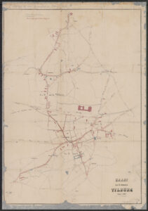
This week we are looking at an often overlooked part of our ancestors' lives: a sewage map. This map shows the network of sewage pipes in Tilburg in 1870. In the 1800s, many municipalities undertook works to improve public health. The cholera outbreak of the 1860s and the discovery of the role of water contamination by raw sewage led to installation of sewage systems all over the country. The Tilburg map shows that by 1870, sewage pipes ran through large parts of the center, though … [Read more...]
Map of the Week – Goeree-Overflakkee over time
5 August 2024 by Leave a Comment

This week we are looking at a map of the island of Goeree-Overflakkee, including two historical maps. The center of the map shows the island as it was in 1842, when the map was created. The island was then called Goedereede en [and] Overflakkee. On the left shows the situation in 1750, when the islands of Goeree and Overflakkee were still seperated at high tide. The right shows the situation around 1300, when the claiming of land had just started. Today, the combined island is part of the … [Read more...]
Map of the Week – Veendam, circa 1868
29 July 2024 by Leave a Comment

Between 1865-1868, Jacob Kuyper published a series of atlases with municipal maps. These show the location of all the hamlets, villages, and larger towns in the municipality, as well as the main roads and railroads. The Kuyper maps are often available at the websites of archives or via Wikimedia Commons. This week we are looking at Veendam, a municipality in Groningen. "Veendam" means "peat dam." The thin rectilinear plots reflects its peat mining history. The area was known for shipbuilding. … [Read more...]

")