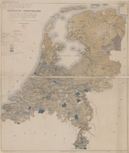
This week we are looking at a thematic map from 1887. It shows the percentage of children between the ages of 6 and 12 who were not in primary school. The statistics were shown per municipality. The darkest blue color represents areas where more than 30% of children did not go to school. A zoomable version is available at Gallica. The map shows great differences between parts of the Netherlands. In general, municipalities in the north had higher school attendance than municipalities in … [Read more...]
Map of the Week – Roermond after city fire, 1671
15 July 2024 by Leave a Comment

This week's map is a drawing of the city of Roermond in 1671. It shows the effects of the city fire of 31 May 1665. The houses with the blue roofs were spared, the ones with the red roofs had been destroyed and rebuilt. Fires were a constant threat to our ancestors. In the seventeenth century, many houses were still built with or from wood. Increasingly, cities passed ordinances requiring houses to be built out of brick, or fill the panels between the timber frames with brick, and to use … [Read more...]
Map of the Week – Overijssel, 1659
8 July 2024 by Leave a Comment

In 1659, the famous mapmaker Joan Blaeu published his world atlas Tooneel des Aardrycks [Display of the Realm of Earth]. The archives in Leiden have made their atlas available online. This week we are looking at his map of Overijssel. It shows the IJssel river on the west, which connected the to the North Sea in the north and the Rhine river in the south, bringing prosperity to the area. The area of Twente in the east shows different cities, including Oldenzaal ("Oldenzeel" on the map), where … [Read more...]
Map of the week – Reclaimed land in North Groningen, 1685
1 July 2024 by Leave a Comment

This week's map shows us land that was reclaimed from the sea by building a dike in the north of the province of Groningen. This includes land in the parishes of Hornhuizen, Wierhuizen, Pieterburen, Westernieland, Saaxumhuizen, Den Andel, Breede, Warffum, Usquert, and Uithuizen. The map was created in 1685 and lists all the owners of the land. Maps like this can be a great source of information to learn about property owned by your ancestors. … [Read more...]
Map of the Week – Plan to drain the South Sea, 1891-1892
24 June 2024 by 2 Comments

In 1891, Cornelis Lely came up with a plan to claim more land from the sea. His ambitious plan involved building a dike between North Holland and Friesland to close off the Zuiderzee [South Sea]. That would make it possible to reclaim large sections of land and create a fresh water lake, the IJsselmeer. This plan formed the basis of a major water engineering project carried out in the first half of the 1900s. In 1932, the dike was completed. The southern (Flevopolder) and eastern (Noordoost … [Read more...]
Map of the week – Maastricht, 1585
17 June 2024 by 2 Comments

In 1585, Braun and Hogenberg published an atlas with maps of different cities in Europe, including many in the Netherlands. This map shows Maastricht. What is nice about these maps is that it shows the people in their local costumes. It shows all the houses in the city, and you can see the different expensions. The detail shows the main church in Maastricht, the St. Servaas. The blue color of the roof indicates it is an untaxed building, usually either religious or city buildings. You can see … [Read more...]
Map of the Week – Goes, 1867
10 June 2024 by Leave a Comment

Between 1865-1868, Jacob Kuyper published a series of atlases with municipal maps. These show the location of all the hamlets, villages, and larger towns in the municipality, as well as the main roads and railroads. The Kuyper maps are often available at the websites of archives or via Wikimedia Commons. This week we are looking at Kuyper's map of Goes, in the province of Zeeland in 1867. It shows that Goes had a railroad connection to Bergen op Zoom and a railway station just south of the … [Read more...]
Map of the Week – Tourist map of Oisterwijk, 1933
3 June 2024 by 2 Comments

This week we are looking at a tourist map of Oisterwijk from 1933. It is a "wandelkaart" [walking map], which highlights various natural features like lakes (blue), forests (green), national forests (orange), swamps (blue horizontal stripes). It features the hotels in the area and places of interest including churches, a swimming pool, and cafes. The early 1900s saw the rise of tourism for the middle and upper classes. Railroads allowed people to travel across the country affordably and … [Read more...]
Map of the Week – Border between Gelderland and Munster near Winterswijk, 1656
27 May 2024 by 3 Comments

This week's map was created in 1656 as part of a conference to settle a boundary dispute between Gelderland and Munster. Around Winterswijk, the border area was covered in moors, and it was unclear where Gelderland ended and Munster started. Farmers from both sides were continuously arguing over who had rights to graze sheep there or collect sods and firewood from those common areas. Nicolaas van Geelkercken was tasked with creating maps showing the border according to Gelderland sources. One … [Read more...]
Map of the Week – Schermer land reclamation, 1635
20 May 2024 by Leave a Comment

This map shows the Scher-meer [Scher lake, also called Schermermeer], a lake that was drained between 1633 and 1635 to claim land. The map shows how this was done: a dike and ditch were built around the lake. Mills would pump water out of the lake, across the dike, into the surrounding ditch, from where it was carried to rivers and ultimately to the sea. Smaller ditches would criss-cross the lake to drain the land. The mills had to continously pump or the lake would fill up again. The Dutch … [Read more...]

")