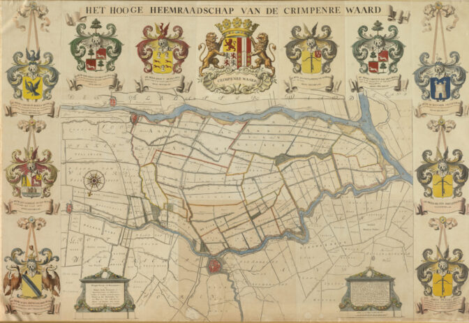
This map shows the water board of Krimpenerwaard, the area around Schoonhoven, south of Gouda in the current province of South Holland. See the waterschap blog post to learn more about water boards.
The map shows the different polders and streams in the water board’s district. The map can help you locate ancestral properties if the polder is noted in land records. Note that the map is oriented with the north at the bottom of the map, as you can see in the compass. The vignette shows that Philip Duke of Burgundy and Jacoba Duchess of Bavaria, countess of Holland, gave several privileges to the Krimpenerwaard on 13 May 1430. This refers to the foundation of the water board.
An interesting aspect of this map is that it shows the names and coats of arms of the people serving on the water board:
- Gerardus Jacobus van den Bosch, magistrate and president of the mayors in Schoonhoven, dijkgraaf (head of the water board).
- Ewout Reykaart, schout (approximately: sheriff/bailiff) and secretary of Stolwijk, water board member
- Jan Smits lord of Ouderkerk aan de IJssel, water board member
- Cornelis van den Bosch, magistrate and former mayor of Schoonhoven, water board member
- Reynier Swanenburg, MLaw, magistrate and former mayor of Gouda, water board member
- Pieter Smits Janszoon, water board member
- Jan Smits Pietereszoon, secretary and treasurer, schout of Ammerstol, schout and secretary of Berkenwoude and Afterbroek, schout and secretary of Berg-Ambagt
- Cornelis Roels Arnoudsz, lord of Waarder, magistrate and mayor of Schoonhoven, water board member
- Jan Verryst lord of Oucoop, secretary of Gouda, water board member
- Jan Arend van der Burgh, MLaw, magistrate and former alderman of Gouda, secretary of the water board.

Map of the Krimpenerwaard water board, 1792. Credits: Schieland and Krimpenerwaard water board


Congratulations! Think I read part of your dissertation when I asked why people emigrated to Iowa. It was well-written and informative and I am glad they chose yours for award – you deserve it!
Happy Holidays.