This map of Overijssel was originally created by Nicolaas ten Have and printed by Frederik de Wit in 1680. Such maps can be useful to understand the location where your ancestor lived. It shows the major roads and rivers. It also shows the jurisdictions, in this case the Land van Vollenhove in blue, Salland in yellow, and Twente in pink. The map shows some local features like noble manors, castles, water mills, and quarries. … [Read more...]
Map of the Week – Overijssel, 1659
In 1659, the famous mapmaker Joan Blaeu published his world atlas Tooneel des Aardrycks [Display of the Realm of Earth]. The archives in Leiden have made their atlas available online. This week we are looking at his map of Overijssel. It shows the IJssel river on the west, which connected the to the North Sea in the north and the Rhine river in the south, bringing prosperity to the area. The area of Twente in the east shows different cities, including Oldenzaal ("Oldenzeel" on the map), where … [Read more...]
Quick tip: Difference between Twente and Achterhoek
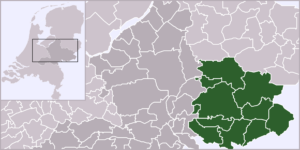
There are two regions in the east of the Netherlands that often get confused: Twente and the Achterhoek. Twente is the eastern part of the province of Overijssel. Major towns are Enschede, Hengelo, Almelo, and Oldenzaal. The Achterhoek is the eastern part of the province of Gelderland. Major towns are Winterswijk, Groenlo, Lochem, and Zutphen. … [Read more...]
Overijssel Research Guide
Overijssel is a province in the east of the Netherlands. It borders on Germany in the east, Drenthe and Friesland in the north, Gelderland to the south and Flevoland and Gelderland to the west. The capital city of Overijssel is Zwolle. The largest towns are: Enschede Almelo Hengelo Oldenzaal Deventer … [Read more...]


