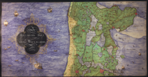
Around 1573, cartographer Christiaan sGroten created an atlas of the Netherlands and Germany for the King of Spain. At this time, the Netherlands were part of the Habsburg empire, headed by King Philip II of Spain. The Dutch Revolt had started several years earlier and the Spanish king needed maps for strategic purposes and commissioned the atlas. The atlas has been digitized and is available at the Royal Library of Belgium. The map we are looking at this week shows a part of the province of … [Read more...]
- Home
- Services
- Fees
- Example projects
- Testimonials
- Blog
- About
- Contact
- 23 December 2024
About

Yvette Hoitink, MLitt, CG®, QG™ is a professional genealogist, writer, and lecturer from the Netherlands who helps people find their ancestors from the Netherlands and its former colonies, including New Netherland. She has a Master of Letters in Family and Local History from the University of Dundee, and holds the Certified Genealogist and Qualified Genealogist credentials.
Do you need a genealogist in the Netherlands to help you with your research?
Please read what Yvette can do for you.
Free newsletter
Sign up to receive weekly email updates with news about Dutch Genealogy!
Webinar
This Dutch Genealogy webinar gives you a great introduction to researching your Dutch ancestors. Requires a Legacy FamilyTreeWebinar subscription to watch. [Affiliate link]

